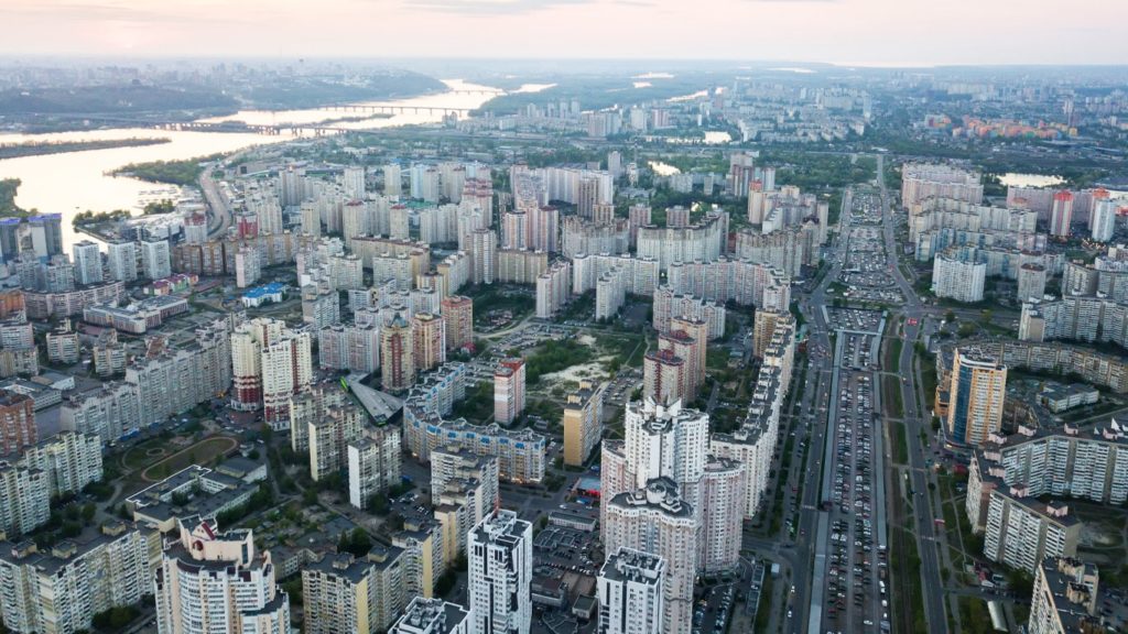
Through aerial photography, you can capture images of objects and areas from the air. For this, you can either utilize an aircraft or other airborne platforms. Broadly speaking, this type of photography allows you to capture snapshots of geographical features of the earth, which also includes revealing its resources. Additionally, it covers the residential and industrial areas that have practical applications. That leads us neatly to the advantages and disadvantages of aerial photography.
Before the invention of unmanned aerial vehicles, aerial photography was dependent on airplanes and helicopters. And as you may have guessed, this was not always an affordable or even feasible option. With technological advancement, we now have the means to take aerial images easily and relatively cheaply.
What is Aerial Photography?
Aerial photography is an intriguing method of capturing images where the camera is elevated high above the ground level. It is like viewing the world from a bird’s eye view. Think of it as if we lent our eyes to a soaring hawk and captured what it sees. The photographers employ aircrafts, drones, helicopters, or even balloons as their equipment for shooting these photographs.
This captivating perspective provides a comprehensive view that is often impossible to capture from the ground. It’s like stepping back from a detailed painting to appreciate the whole masterpiece, with its broad strokes and intricate nuances that contribute to the bigger picture. Aerial photography delivers images that are as breathtaking as they are informative; from sweeping landscapes to city skylines.
How Does Aerial Photography Work?
Let’s imagine trying to conduct a symphony. You’d want to be positioned on a raised platform, enabling a clear view of every instrument. This is quite similar to how aerial photography operates; the elevation provides the comprehensive viewpoint necessary to capture spectacular imagery.
The process typically begins with choosing a suitable flight vehicle. It could be an airplane, a drone, a helicopter, or even a hot air balloon. Once our ‘eye in the sky’ is determined, a suitable camera is mounted onto it. In many cases today, especially with drone photography, cameras come pre-equipped.
Now think of the drone as a remote-controlled airplane you might have played with as a child. The only difference is that now it carries a camera. The drone lifts off the ground, directed by a skilled operator from below who controls its movements. It will then start capturing images or videos from its elevated viewpoint.
The camera adjusts its focus, angle, and other parameters either automatically or manually from the ground, ensuring that it captures the frame as imagined. Once the shooting is done, the drone safely descends and the images are extracted for further processing.
Whether it’s capturing a sunrise that paints an entire city golden or mapping an inaccessible terrain, the mesmerizing world of aerial photography continues to grow and enchant, providing us with a new perspective to perceive our world.
Advantages of aerial photography
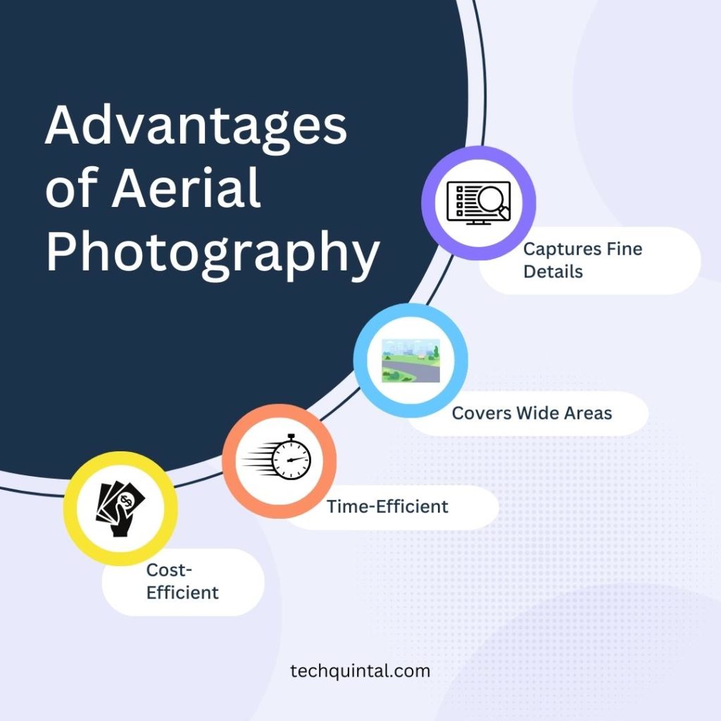
This kind of photography lets you capture aerial photos that can be highly appealing to your audiences. The following are some other benefits you can expect from aerial photography.
1. It captures fine details
Whether you want to capture the images of an object or area, you can count on aerial photography. It captures the subtle details down to spatial resolutions. This gives more depth to the images, and it covers more information.
For instance, potential buyers can make purchase decisions easily when they get accurate aerial images of the property. That way, they can get a better understanding of the property’s location within the community. Not only this, aerial aircraft can reach areas where it is impossible or dangerous to view. This can include anything from rooftops to power lines.
2. Aerial photography covers wide areas
Even though ground photography allows you to capture images of the products or properties from different angles, you still need aerial photography for adding a whole new perspective. It is one of the best tools to attract potential customers. For instance, businesses that have outlets in various locations can use aerial photographs to show their location to the customers.
That way, the potential customers can visualize the location, instead of just reading about it. Additionally, as the images are captured from above, the chances of an obscured view are lower. This brings more clarity and accuracy.
3. It is time-efficient
According to the study conducted by Multiple Listings Service, homes that had aerial images were more likely to sell by 68%. This is because potential buyers got a complete visual of the property through aerial photographs.
A significant amount of time is saved using this form of photography that is otherwise spent searching for potential buyers. Also, the property owner can save their time and resources using unpiloted aircraft rather than climbing on their own to capture those images. These make it a great career opportunity for photographers.
Another great way of putting aerial photography to use is marketing. In marketing, the turnaround time is an important factor. By using aerial photography, businesses can save a lot of time. The aerial photographs can be used to launch the marketing campaign or as a complement. The results of implementing aerial photography in marketing can be quite impressive.
4. Aerial photography is cost-efficient
Earlier only large corporations used to capture aerial photographs as they could afford to hire full-scale equipment such as cranes or helicopters. We won’t even mention the high cost of fuels that came along with it. Today, even small businesses can capture mesmerizing aerial photographs using unmanned aerial vehicles. Advanced technology has made aerial photography cost-efficient. Plus, a single operator can film videos and capture images from these aerial aircraft, eliminating the cost linked with the production crew.
5. It can be used for multiple purposes
Aerial photography has applications in various industries including construction, real estate, agriculture, urban planning, environmental studies, and wildlife monitoring. Construction firms use aerial photography to get a top view of the sites and detect potential problems before they occur. Real estate companies use aerial photos for showing the property to potential buyers.
Similarly, aerial photography is used in agriculture for assessing crop quality and monitoring crop production. It is also used to map out complex areas in urban planning. The reason aerial photography is employed for multiple purposes is that it gives us a bird’s eye view. Therefore, in today’s digital times, these aerial photos are in high demand.
Disadvantages of aerial photography
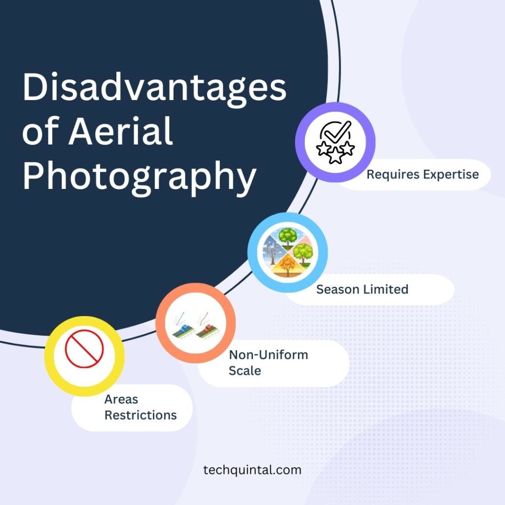
Photography from high above covers a broader area and provides a comprehensive understanding of the site, but it comes with drawbacks. Thus, here goes a list of some downsides of aerial photography.
1. It requires expertise
With aerial photography, you can rely on one person to capture the aerial photos instead of the crew. But this person should be an expert in aerial photography. Although the cost of equipment is not enormous, it is still expensive. Consequently, businesses should hire qualified personnel to avoid the risk of damaging the equipment.
2. Aerial photography is limited by season
During seasonal conditions such as snow cover, capturing images through aerial photography can cause issues. Firstly, the aerial images might not be accurate. Secondly, you can only select from a limited timeline to fly your aerial aircraft for taking images. Therefore, aerial photography is not suitable for some seasonal conditions.
3. It is affected by weather conditions
Aerial photography is dependent on weather conditions. Several factors such as aerial aircraft’s wind speed resistance, the lowest operating temperature, and battery temperature need to be taken into account when deciding to fly them. Furthermore, extreme weather-related circumstances may affect the sensors of aerial vehicles, hence interfering with their ability to detect objects.
4. Aerial photography’s scale is not uniform
The scale of aerial photography is not consistent, meaning there will be distortion. These distortions can be anything from relief displacement to vertical exaggeration. Because of this, you cannot measure factors such as distance, areas, and directions solely from aerial photographs. The distortions must be removed to get an accurate reading of the photo’s subject(s).
5. It is restricted depending on the areas
There are limitations to aerial photography based on locations. For instance, certain locality prohibits the flying of aerial aircraft, especially in populated areas. These restrictions are imposed for the protection of the privacy of the individuals residing in those areas.